


Open data and community mapping for post-earthquake reconstruction in Chocó, Colombia
Posted by Mar Marín Villagrana, Karla Picado, Céline Jacquin • Nov. 11, 2026
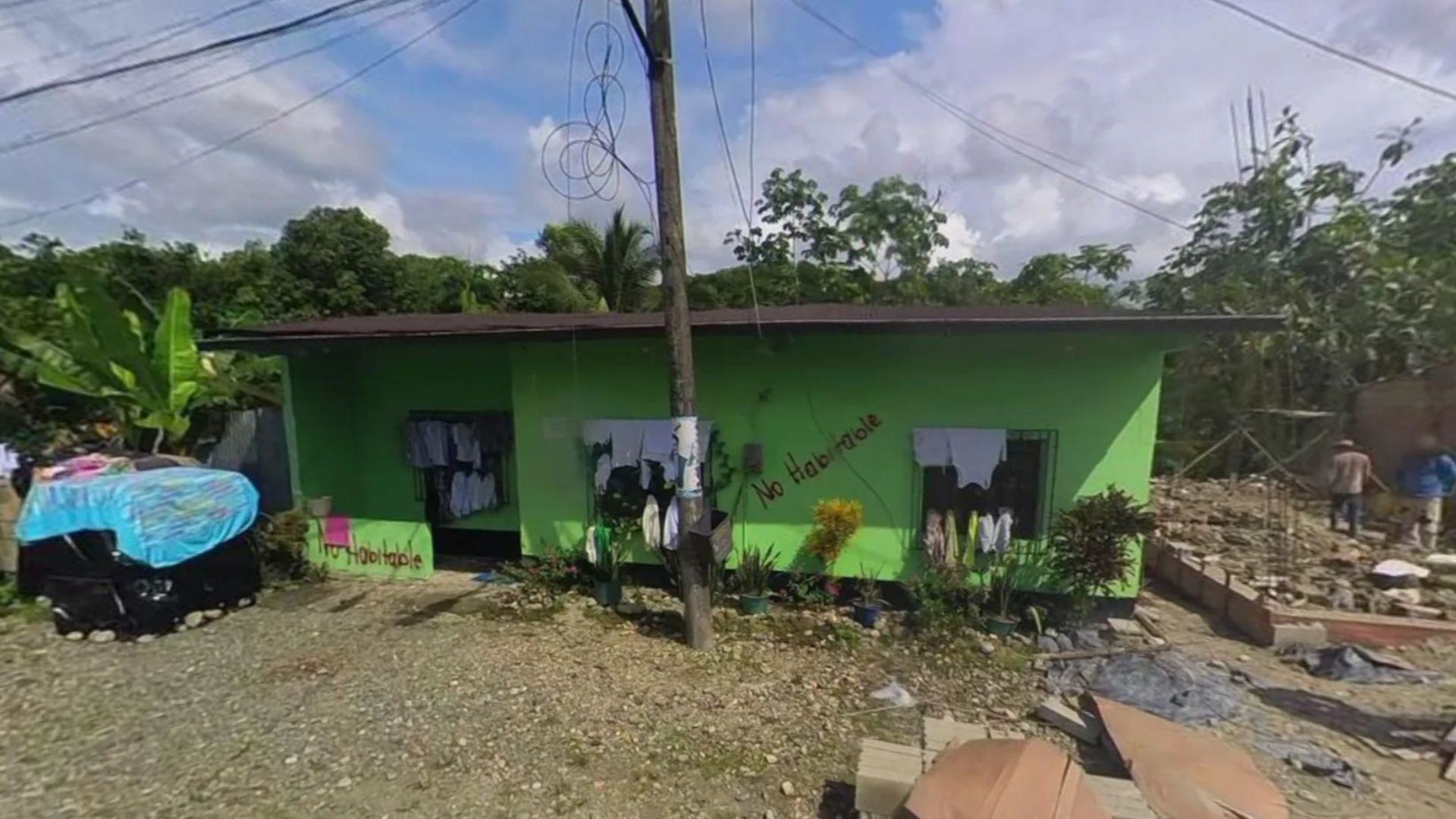
On one street in Condoto, in Colombia’s Chocó department, homes marked “not habitable” stand one after another. Others among them are being rebuilt, and a neighbor repairing his house steps aside to let our team through. All of this was captured in October 2026 through street-level and drone imagery generated collaboratively with local residents and public servants during a field mapping mission. The imagery is now freely available for anyone to use on OpenAerialMap and Mapillary, two open platforms for sharing aerial and street-level imagery.
That walk shows what Chocó needs as it rebuilds: information generated by the people who live there, connected with those who make decisions. Nearly three months after the magnitude 7.4 earthquake of August 10, the territory is so large and the data gaps so wide that local communities are best placed to document their own reality. When that information reaches municipal governments, humanitarian organizations, and other actors leading the recovery, it helps them see where help is still needed and, over time, what impact the reconstruction is having.
What is happening in Chocó
Chocó is moving from emergency response to recovery planning, with urgent needs still unmet. Nationally, Colombia’s National Disaster Risk Management Unit (UNGRD) reported, as of October 9, 486,917 registered people in 500 municipalities across 16 departments, and 243,409 damaged or destroyed homes.
In Chocó, OCHA counted about 112,400 affected people in 30 municipalities in early September, most of them from Afro-Colombian or Indigenous communities. The departmental government estimates that about 5,000 homes must be rebuilt and another 27,000 repaired or improved, at a cost of roughly 4 trillion Colombian pesos.
These figures are still being consolidated. OCHA has pointed to differences in Chocó between damage assessments, departmental and municipal reports, and other sources, which make it harder to identify needs in time. With resources in such high demand, every territory needs its damage and priorities to be clearly visible.
As Chocó is among the most socially vulnerable departments in Colombia, the loss of educational continuity is particularly serious there. In a disaster context, damage to schools and other essential infrastructure must be addressed urgently, even more so in situations of extreme poverty. A distinctive feature of Chocó, however, is the lack of information on where schools are located. It is therefore essential to support their diagnostic mapping and to leverage these learning hubs as spaces for teaching and for building community-based knowledge about the region, now and for the future.
What we are doing in Chocó
This work builds on a foundation laid well before the earthquake. Since 2023, our long-term investment in community resilience has trained 404 people across 31 municipalities in Colombia. Through the project Open Data for Community-Based and Anticipatory Risk Management in Colombia, implemented with National Unit for Disaster Risk Management (UNGRD)’s Sub-directorate for Risk Knowledge and its Community Maps Project, and with support from Twilio, we have left skills and tools, including drones, in the hands of local communities. That same capacity now allows communities to lead the generation of their own data, both to prepare for future emergencies and to document the recovery.

Open Data for Community-Based and Anticipatory Risk Management in Colombia.
Chocó is now also part of the next stage of that work. In North Cauca, a pilot supported by NASA Lifelines combined AI, drones, and fieldwork with local technicians to produce the region’s first comprehensive map of road corridors. That methodology is now scaling to Chocó, where many communities remain unknown due to the lack of high-quality aerial imagery.
In October 2026, part of the HOT team traveled to the municipality of Condoto to generate high-resolution geographic information with the municipal government, strengthen local capacities, and explore new ways of working with organizations in the territory.
For Keyner Mosquera Sánchez, Condoto’s Secretary General and Government and risk management coordinator, the earthquake made the gap clear: “We realized we did need a map to guide us, orient ourselves, and plan the emergency response properly. We are a sixth-category municipality; we do not have the resources to use these technologies.”
Closing that gap was the starting point for the fieldwork, which combined several layers of information:
Drone imagery
Across 483 hectares, the team produced orthophotos of two municipal seats and of a sector near the airport where the municipal government is planning a road project. They give local authorities up-to-date imagery to plan interventions and manage information about their territory.
Street-level imagery
In Opogodó, one of the areas hardest hit by the earthquake, structural damage is not always visible from the air. Mapillary surveys recorded the homes the municipal government has marked “not habitable” and those being rebuilt, along with an overview of building conditions across the area. Together, aerial and street-level imagery offer complementary views of conditions after the disaster.
That evidence matters well beyond the map. Lice Lozano Rentería, Condoto’s Secretary of Economic Development, sees the same gap Mosquera described from another angle: without it, the damage goes unrecognized. In Opogodó, she explained, losses:
“have not been properly reported, because we do not have quality imagery to prove them. Having it would show the reality of what we suffered, what we lived through, and where our community stands today. It would show the needs we now have as a priority.”
For that to happen, the imagery has to stay in local hands and reach those who make decisions. A civil engineer from the municipal government, familiar with GIS and drones, accompanied the fieldwork and helped explain why so many homes collapsed. We are now preparing printed and online maps for the municipality, which had no maps of its own on display, and taking first steps with a local civil society organization to collect community data through ChatMap. Conversations with humanitarian organizations in Chocó have also opened the door to sharing this work in departmental coordination spaces and to using the imagery in municipal land-use planning.
This work adds to the training we are carrying out with municipal governments and community emergency committees in other areas of Chocó, such as Medio Atrato and Bajo Baudó, so they can map their key infrastructure, communication routes, and the communities that do not yet appear on maps.
In Medio Atrato, 16 people from the municipal government, the National Police, and local organizations trained in June 2026 to use drones and open mapping tools to identify areas exposed to risk, and agreed to fly over five communities along the Atrato River. In Sivirú, Bajo Baudó, 13 people from different community councils trained in September; they have started flying over Nuevo Sivirú to identify areas prone to flooding at high tide, document their settlements, and plan coconut crops, and will extend this work to neighboring councils such as Usuragá and Concosta.
Why citizen-generated information matters

Learning to report with ChatMap, as part of Open Data for Community-Based and Anticipatory Risk Management in Colombia.
Communities know their territory and produce data that official sources do not yet have. In Condoto, we are also mobilizing civil society organizations to collect geodata with ChatMap, the WhatsApp reporting tool, to document damage to public facilities such as schools and the different recovery processes led by the community. People who know the municipality are best placed to decide where to go next.
That proximity matters. ChatMap has become a key tool for citizen participation in the reconstruction effort. Thanks to this technology, HOT, OSM Colombia, and UN Mappers have built a map that now holds 1,020 verified reports across 52 municipalities, which UNGRD downloads daily as an input for its data catalog. This effort now aims to gain a stronger foothold in Chocó, to provide a comprehensive overview of the territories that are currently overlooked.
A shared map allows different actors to start from the same reading of the territory. Two days after the earthquake, the National Indigenous Organization of Colombia (ONIC) overlaid the USGS shake-intensity map with its settlement registry to prioritize where to send the Indigenous Guard. ChatMap data also feeds IOM's shelter mapping and the 3iS emergency dashboard.
A shared effort
Chocó’s recovery depends on many hands. Our work in the region is supported by Luminate, which has funded our activities in Chocó. Through our alliance with Luminate and Imaginarius, the implementing partner of Potencia, Luminate’s institutional resilience program for organizations in Latin America, we are supporting Colombian organizations to learn ChatMap and other mapping methods, contribute to damage reporting, and make the tool their own on the long term.
We are far from alone in the territory. A broad and growing ecosystem of actors is taking action in support of the Chocó region, including:
- Public institutions: UNGRD, the Chocó departmental government, and municipal governments across the department.
- International organizations and development banks: CAF, the Inter-American Development Bank (IDB), and United Nations agencies such as UNDP, UNICEF, and OCHA.
- Foundations, companies, and civil society organizations: such as Fundación Corona, Bancolombia, WWB Colombia, Vélez Reyes, and Build Change.
- Local organizations: ONIC, the Indigenous Roundtable of Chocó, ACADESAN, and PROGRESA Chocó.
- The open mapping community: OSM Colombia, UN Mappers, and volunteers around the world.
This list is far from complete, and it keeps growing. Open data is useful to all of these actors: the more of them share the same reading of the territory, the easier it is to coordinate efforts and direct resources where they are needed most. If your organization is working in Chocó, we want to engage with you and support your work.
What we want to achieve
- Verification on the ground: communities able to document what has been rebuilt and what is still pending, for example by repeating the same surveys over the months.
- Tracking investment: open data that makes it possible to compare what was announced with what reached each municipality or rural settlement, and to share that evidence with the authorities.
- Coordination among actors: a common map of who is working where, to avoid duplication and show where aid is arriving and where it is missing.
How to get involved
Map affected areas
Join the remote mapping effort on the Tasking Manager and help fill in the data gaps in the areas affected by the earthquake.
Map on the Tasking Manager →Report damage and progress
Send on-the-ground reports from WhatsApp to ChatMap Colombia and help track damage and recovery as it happens.
Report on ChatMap Colombia →Share drone imagery
Have drone imagery of an affected area? Share it openly through OpenAerialMap so it can support damage assessment and response decisions.
Share on OpenAerialMap →Coordinate with us
Does your organization work in Chocó? Let's coordinate on data so that efforts on the ground and remote mapping complement each other.
Write to hublac@hotosm.org →Share